

My Mom and brother Greg and his family live in Conway, Arkasas, (where I am now) and every time I visit I'm perplexed by the geomorphology I see. Conway has boomed in the last couple of decades--it's a bedroom/white flight community; lots of people who live here work in Little Rock, which lies 20 minutes down I-40 to the south. My visits are short, and through the windshield I see lots of flat surfaces and low-gradiet urban channels (many small, rectangular, and lined with concrete). But also steep, linear scarps and ridges along with some rolling landscapes. Nothing seems to fit together.
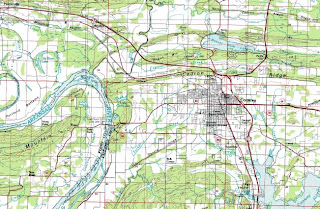
Here's an excerpt from the USGS 1:100K topo and the Arkansas Geological Survey map of the state's geology (link to an About.com article with high-res originals and other things here.) The image of this entire map shows the strong break between the relatively flat Mississippi Delta/Embayment and Gulf Coastal Plain in the eastern and southeastern parts of the state and the mountainous northwest formed with parts of the Ozarks, Boston Mountains, and Ouachitas (see the About.com article for a better description.)
I finally took the time (Kate's napping and Mom's cooking) to examine this, (be warned I'm not in my element here and could be way off.) Conway sits in a severely folded and faulted geologic setting, and it appears the valleys between fold ridges have been filled with alluvium/colluvium. The drainage in Conway is generaly low slope and poorly developed; and Tucker Creek running southwest from town, like many of the smaller channels in town, has been straightened.
Conway lies at about 300 ft. NGVD; a broad terrace in the Arkansas River floodplain 25 feet lower at 275, and a narrow active floodplain at 250 ft. The valley floor at Conway is not mapped as Quaternary alluvium (yellow on the map here) as is the material in the Arkansas River floodplain. There is no obvious break between the flat surface on which Conway lies (is there another name for this, perhaps?) and the Arkansas River terrace at 275 ft.
South of Conway, these eroded strata form aptly named Round Mountain, with an annular drainage pattern I've seen only in textbooks before--you can just see this on the 1:100K excerpt.
Conway's economy doesn't fit with its surrounding very well either--unlike most of the rest of the US, it's booming (resulting in an urban sprawl disaster), largely because of development of the Fayetteville Shale for gas production.Labels: arkansas, geomorphology


